Debbie:
Atlantic hurricanes, for example, originate off the coast of West Africa,
where "tropical disturbances" form in low-pressure zones.
A disturbance
may intensify into a "tropical depression," surrounded by a high-pressure
zone that helps contain the storm, which is centered on a column of rising
air. Winds are moderate: 21 to 35 miles per hour.
Once the
winds exceed 35 miles per hour, the system, now called a "tropical storm,"
gets an alphabetical name. The storm now has the circular structure of
a hurricane, although it may not become one.
Powered
by solar heat that was stored in the ocean and then transferred into the
warm, moist air, the tropical storm becomes a hurricane once winds exceed
74 miles per hour. (More on hurricane formation.)
You might
expect a rotating storm to whirl itself apart, but hurricanes feed on themselves
to gain strength. In their energy flow, hurricanes resemble large thunderstorms.
But while thunderstorms can start over land or water, hurricanes only start
over water. Hurricanes also last much longer, carry far greater energy,
and cause much greater destruction. (More on storm comparisons and hurricane
formation.)

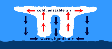
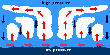
Tropical
cyclones are powered by heat engines -- "machines" that use heat to do
work. In a hurricane, the work comes in the form of driving furious waves
and winds. The hurricane sucks in warm, humid air from the lower atmosphere.
The air rises and condenses, releasing water vapor and the stupendous amount
of heat energy that the moisture absorbed as it evaporated from the ocean.
Finally, the storm exhausts this expended air into the upper atmosphere.
Define "stupendous"?
The average hurricane releases heat energy equivalent to 200 times the
global production of electricity! This released heat drives hurricane winds
and powers the upward convection in the storm (convection is the movement
of lighter fluids over heavier fluids). The rising air creates a low pressure
area near the ocean that draws in more energy-laden air, feeding the continuing
storm.
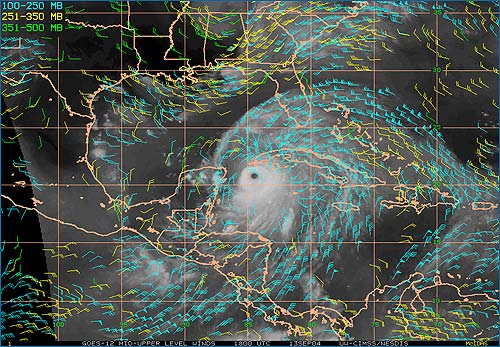
Due to the
Coriolis effect, the lower levels of a tropical cyclone start rotating
counter-clockwise in the Northern Hemisphere, but clockwise in the Southern.
Hurricane
winds whirl around the bizarrely calm "eye," a circular region with little
wind, no rain and often a blue sky. The placid eye is surrounded by a circular
"eyewall" of furious, thunderstorm-type clouds and the fiercest winds.
When Hurricane Camille shredded the U.S. Gulf Coast in 1968, winds in the
eyewall reached 200 miles per hour.
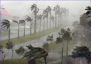 Sept.
4, 2004, Freeport, Bahamas: Hurricane Frances snapped trees, tore up roofs
and flooded parts of Grand Bahama Island. AP
Photo/Andres Leighton Sept.
4, 2004, Freeport, Bahamas: Hurricane Frances snapped trees, tore up roofs
and flooded parts of Grand Bahama Island. AP
Photo/Andres Leighton
Gargantuan
winds, combined with extremely low atmospheric pressure near the eye, cause
a catastrophic rise in sea level called a storm surge. This destructive
mound of water, topped with furious, wind-whipped waves, can hoist the
surface 20 feet above average sea level, causing biblical-scale flooding
along coastlines. In 1899, the Bathhurst Bay hurricane produced a record
record storm surge of 13 meters!
A storm
surge in New Orleans could spell disaster -- the city is well below sea
level, and flooding could be catastrophic. As we write, the city has already
begun to evacuate in anticipation of Hurricane Ivan.
Although
storm surges are the most dangerous element of these storms, water causes
another problem: All that condensing moisture eventually falls as torrential
rain. Although hurricane winds slow as they move inland and become deprived
of energy, rains can still be drenching. The record rainfall inundated
Reunion Island in the Indian Ocean in 1966. In 12 hours, a 'cane dumped
45 inches of water!
Hurricanes
come, and hurricanes go, but the overall trend is periodic lulls, followed
by a series of gangbuster years, like the present.
September
11, 2004, West Melbourne, Fla.: Emergency rescue team member Tom Branco
hands out water after Hurricane Frances.Photo:
Jocelyn Augustino, FEMA
Even though
hurricanes don't seem to be getting more intense, damage is increasing,
mainly because of development and torrid population growth in prime hurricane
country: which in the United States includes the Carolinas, Florida and
the Gulf Coast.
The threat
extends further up the Atlantic Coast. A huge storm around New York City
could funnel a 30-foot storm surge toward the city, flooding auto and subway
tunnels and causing fearsome destruction.

|
|
